(Sept. 17, 2014) – It looks like we are going to get an extra day in the 80s this weekend as model data is in agreement with pushing back the arrival time of our next powerful cold front. Sunday now looks like it will start off warmer with highs likely in the 80s through the early afternoon. While we get the increased warmth the timing of the system may also mean a higher chance for severe weather Sunday afternoon with the passing of the front occurring at a time when instability will be at its peak through the day.
Check school delays and closings
Dense fog advisory issued through 10 a.m.
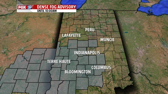
You should expect partly cloudy conditions this afternoon with morning fog setting in early in the day. Visibility this morning will fall to less than a mile in a number of places. At this point it appears places to the west and along the I-70 corridor will be areas most impacted by the fog. There are fog advisories for places across the state including most of central Indiana.
The thickest of the fog is likely to stick around through 10 a.m. Sunrise today is at 7:28 a.m. so expect fog to continue to thicken through at least 8 a.m. As the sun’s angle increases we will begin to see the fog burn off and lift. Winds are light this morning and are expected to remain light throughout the day. They won’t be strong enough to allow some early morning mixing of temperatures that could help to thin out the fog.
The rest of the day
It should be a pleasant September day with highs near 70 degrees. Overall this month we are tracking cooler than the end of month average when it comes to temperatures. The monthly temperature average is 66.9 degrees and our average temperature as of yesterday was 66.9 degrees. Overall the NWS says that we are 2.5 degrees cooler than average right now for the month.
Today should see us push that average down just a bit with a high of just 69 degrees expected. This morning’s low will be in the upper 40s. After the fog burns off it will depend on where you are with regards to how much sunshine you see. Places to our south will see partly to mostly cloudy skies as a weak disturbance passes by to our south. Places north of Indianapolis should see plenty of sunshine all day long. The sunshine or lack of sunshine won’t have a huge difference on temperatures today with places that will likely seeing more clouds being in southern areas of the state where the air mass is not as cool.
Warmer weekend
This weekend is tracking warmer ahead of a cold front that will pull temperatures back down into the 70s for highs early next week. We’ve known that Saturday was going to be warmer and it still looks like that will be the case with a high of 82 expected. The big surprise could be on Sunday with highs now possible hitting the 80s as well. Saturday will definitely be the warmer of the two days with plenty of sunshine and some clouds around. Sunday will be unsettled with winds gusting from the south and overcast skies. Rain chances will stick around all day on Sunday with the cold front passing through during the afternoon. We do have some concerns we could see some thunderstorms due to timing of the system. We will know more today as model data will likely shift to the later solution and we begin to get in stats concerning the severe weather potential. Enjoy your day today!
