Good evening everyone! We saw our first big push of moisture in central Indiana this morning with the heaviest snowfall amounts being reported in the northern part of the viewing area to only freezing rain to the south. We expected this morning round to bring a big mix in precipitation types and it didn’t fail to do just that across the viewing area. Another big push of snow arrived this afternoon as well and that continues to fall across the state especially from Indianapolis and to the south. Some sleet is still mixing in throughout our southern counties.
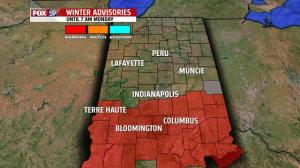
WINTER STORM WARNING: We are still under a winter storm warning until 7 AM Monday through much of the state. While we may not hit the criteria in all of these counties for winter storm warning snow levels, the combination of ice and snow still warrants the warning at this time. The counties still under the winter storm warning include:
- Bartholomew, Brown, Clay, Daviess, Decatur, Greene, Jackson, Jennings, Johnson, Knox, Lawrence, , Martin, Monroe, Morgan, Owen, Rush, Shelby, Sullivan, Vigo, Fayette, Union, Dearborn, Franklin, Ohio, Ripley
As you can see in the attached picture, the winter weather advisory in our northern counties has been dropped. This portion of the state will see little to no additional snowfall out of the waves that are still to arrive this afternoon. While flurries and a light snow shower cannot be ruled out, heavy snowfall is unlikely in this part of the state.
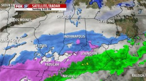
 SATELLITE/RADAR ANALYSIS: We are keeping a close eye on the regional satellite and radar image this evening. There continues to be a large swatch of moisture stretching from the I-70 region in our state back through Illinois and into Missouri. This area of snow will continue moving along the I-70 corridor and continuing snow in our area for several more hours. Snow should cut off here in the city of Indianapolis by 11 PM and our southern counties by 4 AM Sunday. A lot of the moisture from this system was robbed thanks to more active convection through Kentucky and Arkansas. So even though snow did return this evening, it’s a very fine, light snow and not as heavy as the models led on. Yet another disappointment from the weather models on how they handled this storm. But good news if any, at least we got less snow and thus, less headaches going into Monday!
Accumulating snowfall is done in northern Indiana. This portion of the state was dropped from the advisory earlier this afternoon and has seen no new snowfall accumulations this afternoon.
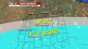
Radar continues to pick up snow along the I-70 corridor and that has brought light snow into places like Greencastle, Avon, Brownsburg, Indianapolis, Noblesville, Lawrence and New Castle. This area will continue to see light snow this evening but only around 1″ of snow should accumulate at this point in addition to what has already fallen. While snow may be showing on radar, it’s just not intense enough to amount to much.
It’s in the southern part of the viewing area where snow will last the longest this evening before cutting off after 4-5 AM and completely ending. This is also a zone where sleet continues to mix in with the snow, so that continues to eat away at those snowfall numbers. There’s the possibility to see 1-2″ of snow in this part of the state in addition to what’s already on the ground.
TONIGHT: Snowfall will continue to push to the south with time in the overnight hours. Temperatures will drop sharply behind this system as arctic air continues to move in to our state. Temperatures should drop into the single digits for Monday morning. Winds will be coming in from the north at 10 to 15 mph so feels like temperatures will dip below zero to start the day. Wind chill values as low as -10°F are possible.


